


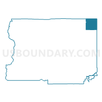
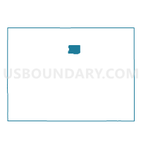
Boulder 234, Boulder County, Colorado
About
Outline

Summary
| Unique Area Identifier | 546955 |
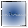
| Name | Boulder 234 |
| County | Boulder County |
| State | Colorado |
| Area (square miles) | 16.11 |
| Land Area (square miles) | 14.99 |
| Water Area (square miles) | 1.12 |
| % of Land Area | 93.05 |
| % of Water Area | 6.95 |
| Latitude of the Internal Point | 40.22198830 |
| Longtitude of the Internal Point | -105.08598780 |
Maps

Graphs
Select a template below for downloading or customizing gragh for Boulder 234, Boulder County, Colorado


Neighbors
Neighoring Voting District (by Name) Neighboring Voting District on the Map
- Boulder 176, Boulder County, CO
- Boulder 177, Boulder County, CO
- Boulder 178, Boulder County, CO
- Boulder 179, Boulder County, CO
- Boulder 180, Boulder County, CO
- Boulder 181, Boulder County, CO
- Boulder 182, Boulder County, CO
- Boulder 183, Boulder County, CO
- Boulder 233, Boulder County, CO
- Larimer 423, Larimer County, CO
- Larimer 424, Larimer County, CO
- Weld 200, Weld County, CO
- Weld 208, Weld County, CO
- Weld 237, Weld County, CO
- Weld 245, Weld County, CO
Top 10 Neighboring County Subdivision (by Population) Neighboring County Subdivision on the Map
- Longmont CCD, Boulder County, CO (99,942)
- Johnstown-Milliken CCD, Weld County, CO (25,317)
- Berthoud CCD, Larimer County, CO (11,509)
Top 10 Neighboring Place (by Population) Neighboring Place on the Map
Top 10 Neighboring Unified School District (by Population) Neighboring Unified School District on the Map
Top 10 Neighboring State Legislative District Lower Chamber (by Population) Neighboring State Legislative District Lower Chamber on the Map
- State House District 48, CO (112,104)
- State House District 49, CO (83,740)
- State House District 11, CO (80,189)
- State House District 13, CO (69,892)
Top 10 Neighboring State Legislative District Upper Chamber (by Population) Neighboring State Legislative District Upper Chamber on the Map
- State Senate District 23, CO (188,398)
- State Senate District 15, CO (155,929)
- State Senate District 17, CO (141,285)
- State Senate District 18, CO (122,287)
Top 10 Neighboring 111th Congressional District (by Population) Neighboring 111th Congressional District on the Map
Top 10 Neighboring Census Tract (by Population) Neighboring Census Tract on the Map
- Census Tract 21.03, Weld County, CO (8,009)
- Census Tract 135.08, Boulder County, CO (6,575)
- Census Tract 26, Larimer County, CO (6,317)
- Census Tract 133.05, Boulder County, CO (4,859)
- Census Tract 133.06, Boulder County, CO (4,589)
- Census Tract 132.07, Boulder County, CO (4,276)
- Census Tract 135.06, Boulder County, CO (4,058)
- Census Tract 135.05, Boulder County, CO (3,831)
- Census Tract 132.01, Boulder County, CO (1,531)